
Main menu

  • Home
  • Content
    • Ahead of Print
    • Current Issue
    • Special Issues
    • All Issues
  • Contribute
    • Submit to AUF
    • Author Guidelines
    • Reviewer Guidelines
  • About
    • Overview
    • Editorial Board
    • Journal Metrics
    • International Society of Arboriculture
  • More
    • Contact
    • Feedback
  • Alerts

User menu

  • Register
  • Subscribe
  • My alerts
  • Log in

Search

  • Advanced search
Arboriculture & Urban Forestry

Advanced Search

  • Home
  • Content
    • Ahead of Print
    • Current Issue
    • Special Issues
    • All Issues
  • Contribute
    • Submit to AUF
    • Author Guidelines
    • Reviewer Guidelines
  • About
    • Overview
    • Editorial Board
    • Journal Metrics
    • International Society of Arboriculture
  • More
    • Contact
    • Feedback
  • Alerts
  • Facebook
  • Twitter
  • YouTube
  • LinkedIn
Research ArticleArticles

Miniature UAVs and Photogrammetry—A Novel Approach to Collecting Aerial Inspection Data from Mature Broadleaf Trees

James Roberts and Duncan Slater
Arboriculture & Urban Forestry (AUF) March 2023, 49 (2) 75-89; DOI: https://doi.org/10.48044/jauf.2023.007
James Roberts
James Roberts, Myerscough College, Greenspace Department, Bilsborrow, Lancashire, United Kingdom
  • Find this author on Google Scholar
  • Search for this author on this site
Duncan Slater
Duncan Slater (corresponding author), Myerscough College, Greenspace Department, Bilsborrow, Lancashire, United Kingdom,
  • Find this author on Google Scholar
  • Search for this author on this site
  • For correspondence: [email protected]
  • Article
  • Figures & Data
  • Info & Metrics
  • References
  • PDF
Loading

Article Figures & Data

Figures

  • Tables
  • Figure 1.
    • Download figure
    • Open in new tab
    • Download powerpoint
    Figure 1.

    Photograph of the commercially available hobby drone, a DJI Mini 2® (DJI, Shenzhen, China) UAV, which was used for this study.
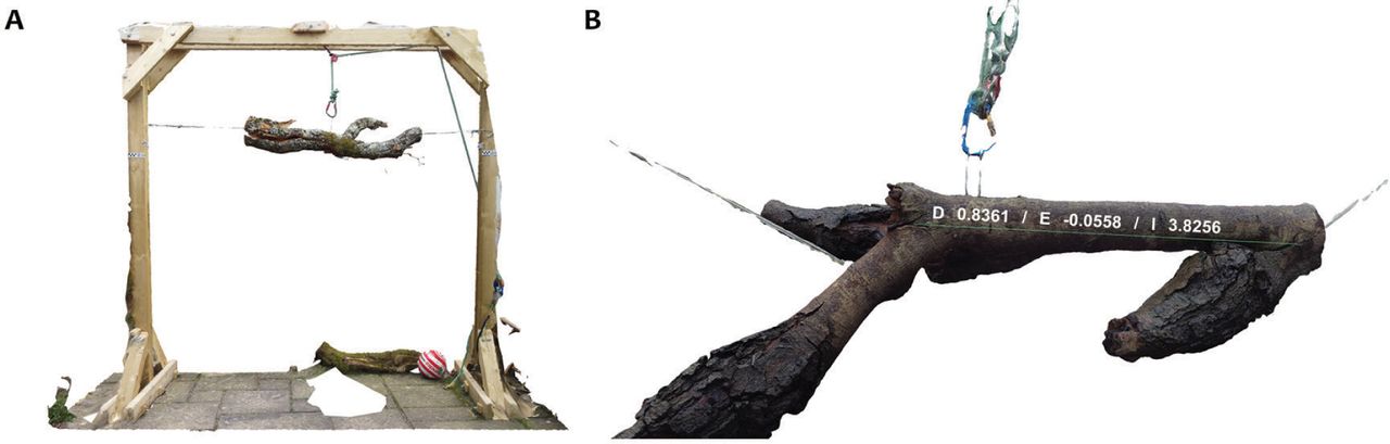
  • Figure 2.
    • Download figure
    • Open in new tab
    • Download powerpoint
    Figure 2.

    A: 3D model of a split oak branch suspended from a timber gantry crane. B: Example measurement along the surface of the 3D model of the branch, carried out within the software program 3DF Zephyr Lite Steam Edition (3Dflow SRL, Verona, Italy).

  • Figure 3.
    • Download figure
    • Open in new tab
    • Download powerpoint
    Figure 3.

    The 4 subject oak trees used in the field trial: T1, top left; T2, top right; T3, bottom left; and T4, bottom right. These were all open-grown trees in a parkland setting.
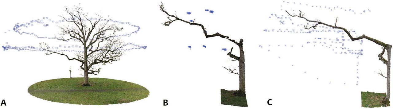
  • Figure 4.
    • Download figure
    • Open in new tab
    • Download powerpoint
    Figure 4.

    Visual representation of the 3 different flight strategies used in this study, where the blue shapes represent camera positions. A: Orbital. B: Cluster. C: Parallel.

  • Figure 5.
    • Download figure
    • Open in new tab
    • Download powerpoint
    Figure 5.

    Screenshot of the T1 FOI models represented as RGB scalar fields within CloudCompare (EDF R&D, Los Altos, CA, USA).

  • Figure 6.
    • Download figure
    • Open in new tab
    • Download powerpoint
    Figure 6.

    Visual comparison between the rendered models for the 4 FOIs (T1, T2, T3, T4) in the order of orbital flight, cluster flight, and parallel flight. For each of the 4 FOIs, the parallel flights provided the most detailed rendering of the shape and surfaces of the FOIs within the photogrammetric models.

  • Figure 7.
    • Download figure
    • Open in new tab
    • Download powerpoint
    Figure 7.

    Images of all 4 FOIs for all 3 flight strategies. The rows represent the FOIs for T1, T2, T3, and T4, respectively. The columns represent the photogrammetric models from the orbital flight, cluster flight, and parallel flight strategies, respectively. In all 4 cases, the level of visual detail and accuracy is noticeably better for the images generated from the parallel flight strategy.
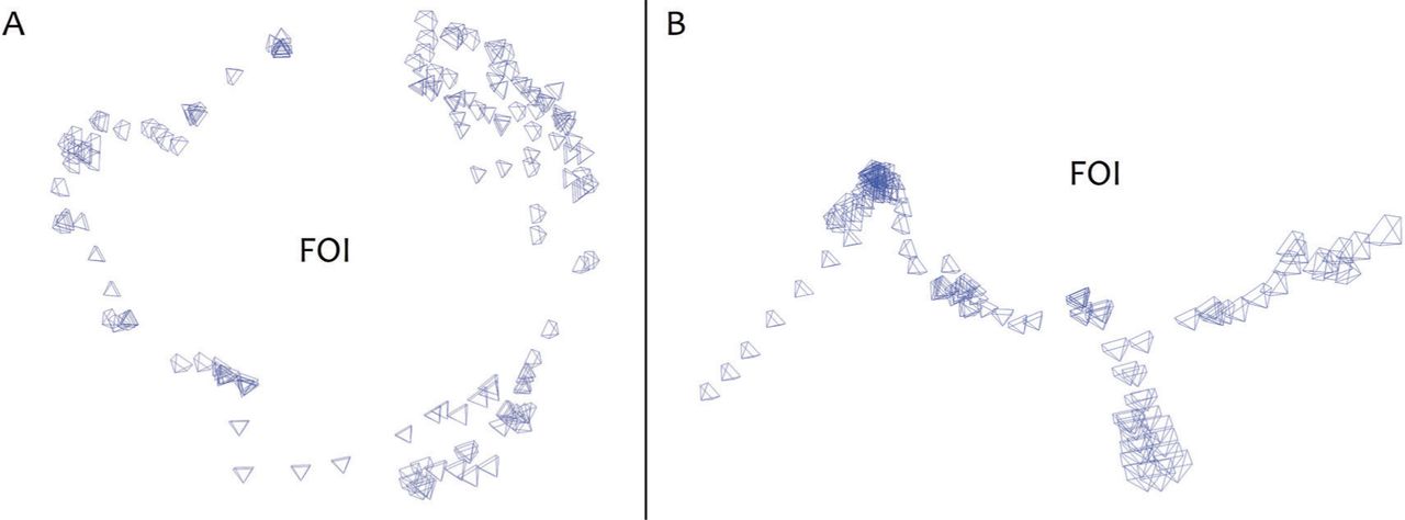
  • Figure 8.
    • Download figure
    • Open in new tab
    • Download powerpoint
    Figure 8.

    Camera maps (camera positions marked in blue) for T1 and T2 parallel flights around FOIs. A: Camera map for the T1 parallel flight, which shows that images taken all around the FOI were used for the photogrammetric model. B: Corresponding camera map for the parallel flight of T2, where the images used for the model were only situated on one side of the FOI, limiting the associated model’s accuracy.

Tables

  • Figures
    • View popup
    Table 1.

    Number of images captured and used in each FOI (feature of interest) photometry model. UAV (uncrewed aerial vehicle).

    FOI tree and flight strategyNo. of images taken by UAVNo. of images used in model% of used images from total images
    T1 orbital34133999.4%
    T1 cluster1593823.9%
    T1 parallel22111953.8%
    T2 orbital345345100.0%
    T2 cluster1746738.5%
    T2 parallel27615857.2%
    T3 orbital406406100.0%
    T3 cluster268268100.0%
    T3 parallel248248100.0%
    T4 orbital344344100.0%
    T4 cluster1784223.6%
    T4 parallel27527399.3%
    • View popup
    Table 2.

    Mean point density for each model generated from the field study, with standard deviation and coefficient of variation. FOI (feature of interest).

    FOI refMean point densityStandard deviationCoefficient of variation
    T1 orbital1.0070.1150.114
    T2 orbital1.0750.4180.389
    T3 orbital1.2230.6020.492
    T4 orbital1.9111.3220.692
    T1 cluster4.6272.0460.442
    T2 cluster4.7253.7990.804
    T3 cluster5.0742.4450.482
    T4 cluster28.02735.0911.252
    T1 parallel32.71917.7190.542
    T2 parallel33.84022.3140.659
    T3 parallel15.4006.4690.420
    T4 parallel35.76529.0780.813
PreviousNext
Back to top

In this issue

Arboriculture & Urban Forestry (AUF): 49 (2)
Arboriculture & Urban Forestry (AUF)
Vol. 49, Issue 2
March 2023
  • Table of Contents
  • Table of Contents (PDF)
  • Index by author
Print
Download PDF
Email Article

Thank you for your interest in spreading the word on Arboriculture & Urban Forestry.

NOTE: We only request your email address so that the person you are recommending the page to knows that you wanted them to see it, and that it is not junk mail. We do not capture any email address.

Enter multiple addresses on separate lines or separate them with commas.
Miniature UAVs and Photogrammetry—A Novel Approach to Collecting Aerial Inspection Data from Mature Broadleaf Trees
(Your Name) has sent you a message from Arboriculture & Urban Forestry
(Your Name) thought you would like to see the Arboriculture & Urban Forestry web site.
Citation Tools
Miniature UAVs and Photogrammetry—A Novel Approach to Collecting Aerial Inspection Data from Mature Broadleaf Trees
James Roberts, Duncan Slater
Arboriculture & Urban Forestry (AUF) Mar 2023, 49 (2) 75-89; DOI: 10.48044/jauf.2023.007

Citation Manager Formats

  • BibTeX
  • Bookends
  • EasyBib
  • EndNote (tagged)
  • EndNote 8 (xml)
  • Medlars
  • Mendeley
  • Papers
  • RefWorks Tagged
  • Ref Manager
  • RIS
  • Zotero
Share
Miniature UAVs and Photogrammetry—A Novel Approach to Collecting Aerial Inspection Data from Mature Broadleaf Trees
James Roberts, Duncan Slater
Arboriculture & Urban Forestry (AUF) Mar 2023, 49 (2) 75-89; DOI: 10.48044/jauf.2023.007
del.icio.us logo Digg logo Reddit logo Twitter logo CiteULike logo Facebook logo Google logo Mendeley logo
  • Tweet Widget
  • Facebook Like
  • Google Plus One
Bookmark this article

Jump to section

  • Article
    • Abstract
    • INTRODUCTION
    • MATERIALS AND METHODS
    • RESULTS
    • DISCUSSION
    • CONCLUSION
    • ACKNOWLEDGMENTS
    • Footnotes
    • LITERATURE CITED
  • Figures & Data
  • Info & Metrics
  • References
  • PDF

Related Articles

  • No related articles found.
  • Google Scholar

Cited By...

  • No citing articles found.
  • Google Scholar

More in this TOC Section

  • Hardscape of Soil Surface Surrounding Urban Trees Alters Stem Carbon Dioxide Efflux
  • Literature Review of Unmanned Aerial Systems and LIDAR with Application to Distribution Utility Vegetation Management
  • Borrowed Credentials and Surrogate Professional Societies: A Critical Analysis of the Urban Forestry Profession
Show more Articles

Similar Articles

Keywords

  • 3D Modelling
  • Arboriculture
  • Drones
  • Tree Risk Management
  • Tree Surveying
  • UAV
  • Visual Tree Inspection

© 2023 International Society of Arboriculture

Powered by HighWire