
Article Figures & Data
Figures
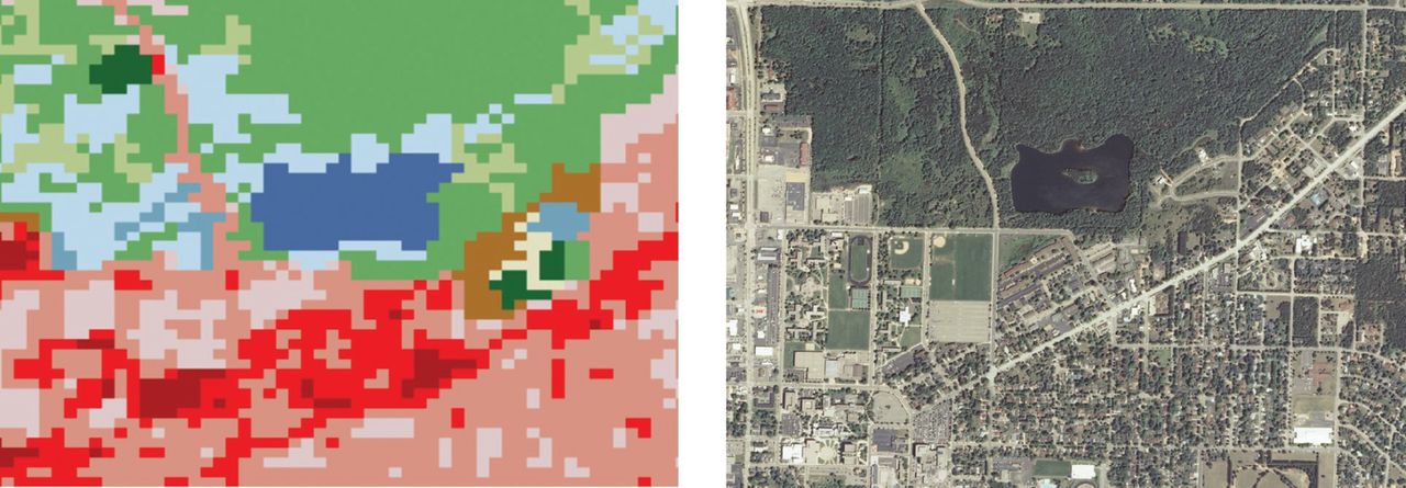
- Figure 1.
Comparison of 30-m resolution National Land Cover Database (NLCD, left image) and approximately 1-m National Agriculture Imagery Program (NAIP, right image) for Schmeeckle Reserve, Lake Joanis, Stevens Point, WI, USA.
- Figure 2.
Tree canopy cover (TCC) percentage using 2-m or better imagery (NAIP or NAPP) or 30-m imagery (NLCD) across the entire city (a); percentage TCC across the entire city or only within the rights-of-way (ROWs) using NAIP or NAPP imagery (b).
- Figure 3.
Box plot comparison of tree canopy cover (TCC) using 2-m or better imagery (NAIP or NAPP) or 30-m imagery (NLCD) across the entire community, or within the rights-of-way only (NAIP or NAPP). Box plot parts are: lower box 1st quartile; line median; X mean; upper box 3rd quartile. Line ends are minimum and maximum values; circles are outliers.


Tables
- Table 1.
Estimation of tree debris (yd3) collected from within public lands and rights-of-way by a community following an ice storm. Modified model based on Hauer et al. (2011). TCC (tree canopy cover); TCCCITY (canopy cover estimate across the entire city).
Variable Unstandardized coefficients Standard error of the mean t-statistic P-value Constant −257,643 72,644 −3.55 = 0.001 Street distance (mi) 638.4 31.9 20.03 < 0.001 Ice (in) 59,307 19,310 3.07 = 0.004 TCCCITY (%) 2,884 1,603 1.80 = 0.081 - Table 2.
Comparison of 2 models to estimate tree debris (yd3) following an ice storm collected by a community using a canopy cover estimate across the entire city (TCCCITY). The NLCD (National Land Cover Database) model variable used 30-m imagery and the NAIP (National Agriculture Imagery Program) and NAPP (National Aerial Photography Program) model variables used approximately 2-m or better imagery. SEM (standard error of the mean); TCC (tree canopy cover).
NLCD Model Adj R2 = 0.949 NAIP/NAPP Model Adj R2 = 0.917 Variable Unstandardized coefficients (SEM) P-value Unstandardized coefficients (SEM) P-value Constant −129,677 (72,644) < 0.001 −257,643 (72,644) = 0.001 Street distance (mi) 655.1 (31.9) < 0.001 638.4 (31.9) < 0.001 Ice (in) 49,426 (19,310) = 0.003 59,307 (19,310) = 0.004 TCCCITY (%) Not Significant = 0.207 2,884 (1,603) = 0.081 - Table S1.
Imagery sources and quality used in this study to estimate tree canopy cover (TCC). NLCD (National Land Cover Database); NAIP (National Agriculture Imagery Program); NAPP (National Aerial Photography Program); ND (no data).
City State Ice storm year Imagery date Spectral bandsa Image source Approximate resolution (m) NLCD TCC (%) entire community NAIP/NAPP TCC (%) entire community NAIP/NAPP TCC (%) street rights-of-way Ballwin MO 2007 2006 Three-Band NAIP 2 31.5 54.7 37.6 Bath ME 2008 2007 Three-Band NAIP 1 47.1 64.8 47.6 Burlington NC 2002 1995 One-Band NAPP 2 16.1 30.4 ND Burlington NC 2003 1995 One-Band NAPP 2 16.1 30.4 ND Decatur IL 2006 2005 Three-Band NAIP 2 11.7 40.4 39.0 Ellisville MO 2006 2005 Three-Band NAIP 2 ND 53.0 40.4 Euclid OH 1996 1994 One-Band NAIP 3.5 9.0 28.1 ND Evansville IN 2009 2008 Four-Band NAIP 1 10.2 27.1 24.1 Exeter MO 2007 2005 Three-Band NAIP 2 3.3 27.7 27.0 Fayetteville AR 2009 2006 Three-Band NAIP 2 26.1 42.3 28.9 Forsyth IL 2007 2005 Three-Band NAIP 2 6.2 29.0 19.9 Gladstone MO 2002 1997 One-Band NAPP 2 11.6 30.3 ND Greenville SC 2005 2005 Three-Band NAIP 1 40.2 50.7 48.3 Harrison AR 2009 2006 Three-Band NAIP 2 13.1 37.2 31.8 Henderson KY 2009 2008 Three-Band NAIP 1 11.9 28.9 23.3 Henderson-ville NC 2010 2009 Four-Band NAIP 1 25.7 35.0 42.2 Holden MA 2008 2006 Three-Band NAIP 2 ND 78.5 61.8 Jackson MO 2007 2007 Three-Band NAIP 1 14.7 31.9 23.2 Jefferson City MO 2007 2005 Three-Band NAIP 2 26.3 44.4 31.0 Jonesboro AR 2009 2006 Three-Band NAIP 2 24.9 31.6 24.4 Leesburg VA 2007 2006 Three-Band NAIP 2 11.3 31.0 30.3 Leominster MA 2008 2006 Three-Band NAIP 2 50.8 64.6 52.2 Lincoln IL 2006 2005 One-Band NAIP 2 4.0 35.6 39.2 Litchfield CT 2001 1998 One-Band NAPP 3.9 51.2 ND ND Maryville MO 2007 2005 Three-Band NAIP 2 4.2 21.0 23.6 Mayfield KY 2009 2008 Three-Band NAIP 1 9.8 30.8 26.4 Mountain Home AR 2009 2006 Three-Band NAIP 2 19.7 42.0 27.6 Owensboro KY 2009 2008 Three-Band NAIP 1 7.0 21.0 19.7 Paducah KY 2009 2008 Three-Band NAIP 1 14.1 36.1 31.2 Raleigh NC 2002 1999 Three-Band NAPP 0.5 32.8 53.4 39.4 Richmond Heights OH 2006 2005 Three-Band NAIP 2 18.6 49.3 38.5 Savannah MO 2007 2006 Three-Band NAIP 2 5.1 27.8 29.9 Sidney OH 2005 2004 Three-Band NAIP 1 13.7 27.2 25.5 Sikeston MO 2008 2007 Three-Band NAIP 1 4.3 15.6 25.5 Sikeston MO 2009 2007 Three-Band NAIP 1 4.3 15.6 25.5 Springfield MO 2007 2005 Three-Band NAIP 2 11.7 39.9 36.3 St. Louis MO 2006 2005 Three-Band NAIP 2 7.9 16.0 31.5 St. Peters MO 2007 2005 Three-Band NAIP 2 10.0 26.9 24.5 Tulsa OK 2007 2006 Three-Band NAIP 2 10.1 33.9 32.5 Winchester VA 2007 2006 Three-Band NAIP 2 9.1 33.0 31.7 ↵aFour-Band (Natural Color/Color Infrared); Three-Band (Color); One-Band (Black and White)


Jump to section
Related Articles
Cited By...
- No citing articles found.