
Abstract
Planning to prepare for storms should involve the estimation of tree debris. This paper tested an improvement of a rapid estimation model of tree debris following ice storms. An initial model found using 30-m resolution National Land Cover Database (NLCD) tree canopy cover (TCC) data did not significantly (P ≈ 0.20) improve estimation of tree debris within a community right-of-way (ROW) following an ice storm. We tested if finer resolution National Agriculture Imagery Program (NAIP) TCC imagery (2-m resolution or better) could more accurately predict tree debris after an ice storm. Tree canopy cover was estimated with NAIP across the entire community (TCCCITY) and also the area that only covered the ROW plus a 15.24-m (50-foot) buffer on each side (TCCROW). The TCCCITY (P = 0.08) estimate marginally improved tree debris prediction in the overall multiple regression model (R2 adj = 0.917; F = 133.8; df = 3,33), but this was not the case with the TCCROW (P = 0.66) estimate. The TCCCITY estimate was 34.7% (SEM = 2.0) and significantly (P < 0.001) 2 times greater than in the 16.2% (SEM = 2.2) TCC estimate from NLCD imagery. We found the TCCROW was 32.6% (SEM = 1.6) and significantly lower (P = 0.003) than in TCCCITY. Results from this study may improve the overall ability to predict tree debris following ice storms from the regional models currently used to a more local estimate for a city. Future investigations are needed to determine if this is the case.
INTRODUCTION
Ice storms occur annually throughout the eastern United States and Canada as well as other places throughout the world (Changnon 2003; Hauer et al. 2006). They vary in intensity from minor ice accumulation of approximately 0.64 cm (0.25 in) that causes little or no damage, to a much greater thickness of precipitation in excess of 5 cm to 10 cm (2 in to 4 in) on surfaces, which can cause remarkable tree damage (Hauer et al. 1993; Hauer et al. 2006; Greene et al. 2007; Klopčič et al. 2020). Monetarily, ice storms result in hundreds of millions of dollars (USD) in annual loss and potentially billions of dollars in losses from property and tree damage during extreme and widespread ice storms (Hauer et al. 2006; Call 2010; Degelia et al. 2016). Damage also occurs to electrical grid systems, roadways, and property from fallen trees and branches, disrupting normal community functions (Call 2010). However, not all trees are severely damaged, as the resistance of tree species to ice accumulation varies (Hauer et al. 1993; Hauer et al. 2006; Coder 2017; Klopčič et al. 2020). Certain characteristics, such as weak branch attachments, indicated by included bark, dead and decaying branches, a broad crown, and fine branching, increase a tree’s susceptibility to damage from ice and wind (Hauer et al. 2006; Staudhammer et al. 2009; Coder 2017; Klein et al. 2020).
Following an ice storm, a community often faces the cleanup of tree debris. The debris amounts can be substantial, and a coordinated effort to plan for debris removal is ideal (Escobedo et al. 2009; Schmitt-Harsh and Wiseman 2020; Nowak et al. 2022; Salisbury et al. 2022). The estimation of tree debris following a storm has been calculated using various methods ranging from on-the-ground, airborne laser scanner, aerial imagery, and prediction equations (King et al. 2005; Hauer et al. 2011; Rahman and Rashed 2015; Wu 2019). For example, Wu (2019) used Normalized Difference Vegetation Index (NDVI) values to estimate tree biomass and debris through satellite imagery. Predictive models use a combination of community attributes (e.g., street distance, community area, housing density) and storm parameters (e.g., ice accumulation, mean wind speed, maximum wind gusts, foliage presence) to estimate debris (Escobedo et al. 2009; Hauer et al. 2011). A field-based system uses inventory plots along the public rights-of-way (ROWs) to assess trees pre-storm in comparison to post-storm damage, which is used to estimate debris throughout the community (Bloniarz et al. 2001; Bond 2005).
Due to the labor and monetary needs required to recover after an ice storm, developing greater ice-storm resistance in tree populations through tree selection and management practices to minimize damage is an ideal forethought for communities (Hauer et al. 2006; Hauer et al. 2011), in addition to predicting potential debris before a storm or conducting a thorough estimation after. Hauer et al. (2011) developed a method by which communities can estimate tree debris following ice storms. They found that total street distance or total community land area and the ice thickness of the storm were significantly related to total debris. Tree canopy cover (TCC) was hypothesized to be a significant predictor (factor) in debris estimation. However, Hauer et al. (2011) found that coarse 30-m resolution National Land Cover Database (NLCD) TCC data did not significantly predict debris. Nowak and Greenfield (2010) found that NLCD imagery significantly underestimates TCC, which possibly explains an issue using NLCD TCC derived data as a debris predictor. Having no trees would result in no tree debris, and it seems logical that as tree density and biomass within an area increase, more potential tree debris is possible after a storm. Thus, TCC is a potential proxy for estimating tree abundance, and finer resolution imagery might improve the ability for this variable to estimate tree debris following an ice storm.
The aim of this research was to test if improved TCC estimates based on finer resolution imagery (approximately 1 m to 2 m) would improve the debris estimation models compared to models that use coarser resolution imagery (approximately 30 m). We hypothesized that the finer resolution TCC would be a significant predictor of debris associated with ice storms. We also hypothesized that street distance (or the area of a community) and ice thickness would be significant predictors. We further hypothesized that TCC estimates from finer resolution imagery (approximately 1 m to 2 m) would be higher than coarser resolution imagery (approximately 30 m). Finally, we hypothesized that debris estimates using TCC from within the ROW would be more accurate than a citywide TCC estimate.
MATERIALS AND METHODS
Site Locations and Data Sources
This study tested the potential improvement of ice storm debris estimation using TCC estimates based on finer resolution imagery. Methods and data from Hauer et al. (2011) for communities in 15 eastern states (USA) were used, with the exception of replacing the TCC estimates. The TCC modification was made by replacing 2001 NLCD 30-m resolution tree canopy imagery with National Agriculture Imagery Program (NAIP) data at an approximate 2-m or better resolution. Figure 1 shows an example difference between NLCD and NAIP imagery and the subsequent ability to estimate tree canopy. In cases where NAIP was not available, National Aerial Photography Program (NAPP) imagery was used, providing data for 5 communities with ice storms before 2001.
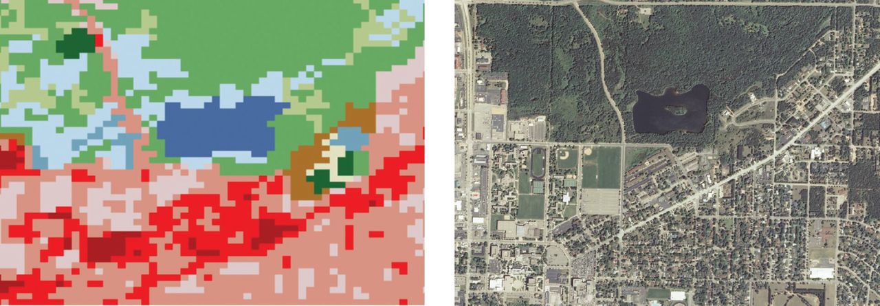
Comparison of 30-m resolution National Land Cover Database (NLCD, left image) and approximately 1-m National Agriculture Imagery Program (NAIP, right image) for Schmeeckle Reserve, Lake Joanis, Stevens Point, WI, USA.
Imagery was selected from the nearest date prior to the ice storm for the communities in this study. Most imagery (81%) was within 1 (53%) or 2 (28%) years prior to the ice storm and the remaining within 3 (17%) or 5 (3%) years. The imagery was paired with a municipal boundary shapefile in ArcGIS (ArcMap 10.5.1, Redlands, CA, USA). Image quality (e.g., image resolution) and data sources are found in the Appendix. A total of 1,000 locations as sample points were randomly located within the municipal boundary using the Create Random Points tool, and each was evaluated as landing on tree canopy (1), or not (0), and recorded as such in the ArcGIS attribute table for each location. Percentage TCC was calculated as:

and calculated for the entire city (TCCCITY). Tree canopy cover (TCCROW) was also estimated by buffering for trees just within the public rights-of-way (ROWs) plus an additional 15.24 m (50 ft) beyond the ROWs on each side. This TCCROW buffer accounted for trees on public land and for either trees adjoining the ROWs that may become damaged and fall within the ROWs, or tree debris brought into the ROWs by adjoining landowners. The TCCROW could include debris that was brought to the curb from the resident’s private property and mixed with tree debris that fell within the municipal ROWs.
Statistical Approach
Multiple regression models were used to predict tree debris (yd3) as a dependent variable. Ice thickness (in), street miles (mi), and each TCC type (TCCCITY and TCCROW) were separately used as independent variables to predict tree debris. Results are presented in English with SI equivalent units, as these English parameters are the metrics used by communities in the United States to monitor debris collection. Model parameters used P < 0.10 for final inclusion.
RESULTS AND DISCUSSION
Tree Canopy Cover Estimates Based on Two Resolution Types
We found that TCC was 2 times greater (P < 0.001, df = 36, t = 18.480) using approximately 2-m or better NAIP imagery (34.7%, SEM = 2.0) than 30-m NLCD imagery (16.1%, SEM = 2.0)(Figure 2a). The TCCCITY (37.1%, SEM = 2.5) was greater (P = 0.003, df = 34, t = 3.264) than in the TCCROW (32.6%, SEM = 1.6) (Figure 2b). Thus, the NLCD imagery underestimated TCC compared to both NAIP estimates in this study (Figure 3). The NLCD imagery is known to underestimate TCC; as such, our findings were not surprising (Nowak and Greenfield 2010).

Tree canopy cover (TCC) percentage using 2-m or better imagery (NAIP or NAPP) or 30-m imagery (NLCD) across the entire city (a); percentage TCC across the entire city or only within the rights-of-way (ROWs) using NAIP or NAPP imagery (b).

Box plot comparison of tree canopy cover (TCC) using 2-m or better imagery (NAIP or NAPP) or 30-m imagery (NLCD) across the entire community, or within the rights-of-way only (NAIP or NAPP). Box plot parts are: lower box 1st quartile; line median; X mean; upper box 3rd quartile. Line ends are minimum and maximum values; circles are outliers.
Tree Debris Estimation
The NAIP estimate for TCCCITY improved tree debris prediction (P = 0.08) in the overall multiple regression model (R2 adj = 0.917; F = 133.8; df = 3,33) in Table 1. Within the studied location, for each percent of TCCCITY, a total of 2,884 yd3 (2,205 m3) of tree debris is expected. Using TCCROW as a predictor was insignificant in our multiple regression model (P = 0.66). This finding was contrary to our hypothesis that it would be a better predictor than TCCCITY. One explanation is that tree debris from city parks would not be captured in the TCCROW model. Additionally, it is possible that residents also moved tree debris from areas beyond the TCCROW area, such as from back and side yards, and placed it on the curb for accumulation. The effect of street distance on debris estimation decreased from 655.1 yd3 (500.9 m3) of tree debris per street mile (1.61 km) to 638.4 yd3 (488.1 m3) in the updated model (Table 2). The ice thickness predictor also increased with each inch (2.54 cm) of ice, accounting for 59,307 yd3 (45,343 m3) of tree debris in a community. Tree debris from storms is one component of annual tree biomass in the urban forest (Nowak et al. 2019).
Estimation of tree debris (yd3) collected from within public lands and rights-of-way by a community following an ice storm. Modified model based on Hauer et al. (2011). TCC (tree canopy cover); TCCCITY (canopy cover estimate across the entire city).
Comparison of 2 models to estimate tree debris (yd3) following an ice storm collected by a community using a canopy cover estimate across the entire city (TCCCITY). The NLCD (National Land Cover Database) model variable used 30-m imagery and the NAIP (National Agriculture Imagery Program) and NAPP (National Aerial Photography Program) model variables used approximately 2-m or better imagery. SEM (standard error of the mean); TCC (tree canopy cover).
Tree Debris Model Application
The model estimates for debris in this paper predict a volume associated with the near-term collection of tree biomass within public ROWs. Additional woody debris occurs on private property. Tree debris that is collected and reimbursed through United States Federal Emergency Management Agency disaster declaration is restricted to public property (FEMA 2018). The debris estimates from communities used to develop this model were based on debris placed within a public ROW (Hauer et al. 2011). This included debris from trees within the public ROW and debris that was placed in the ROW from private tree debris that either fell or was placed in the public ROW. Additional tree debris occurs on private land that was not accounted for in the model, which a community would normally collect within a few weeks to months following an ice storm.
It is not uncommon for additional tree debris resulting from storms to occur several months or even years later, either from failure initiated by the storm or people’s decisions (e.g., people may decide to remove trees due to concern of future failure)(Hauer et al. 2006; Conway and Yip 2016). The model in this paper does not account for this. In addition, trees may become damaged by ice storms and not immediately fail from the storm (Shortle et al. 2003; Luley and Bond 2006; Greene et al. 2007). For example, tree branches may become cracked from ice loading and then, during a later loading event (e.g., wind, ice, foliage), fail and become debris (Zipperer et al. 2004; Greene et al. 2007; Kraemer and Nyland 2010; Coder 2017). While it is important to account for these additional residual sources of debris, the intent of this current model is to rapidly predict potential tree debris volumes during the near-term collection of debris. Thus, the modified model in this paper is intended to make local and regional estimates of debris collected by a municipality soon after ice storms (e.g., weeks to a few months). These estimates could be used then to plan for labor and equipment needs and estimate the potential costs for state and federal recovery funding.
CONCLUSION
Storms are a common urban forest disturbance factor resulting in tree damage and debris. Ice storms are one such common storm in eastern North America. Proactively estimating the volume of debris, or rapidly estimating potential debris soon after a storm, is important for planners. This study used an improved tree canopy estimate within a tree debris estimation model. We found marginal improvement using finer resolution imagery. However, the use of the canopy predictor should make a more local-based estimate for a community from a regional predictive model associated with the original model. Finally, ice storm frequency and severity within the eastern United States necessitates the incorporation of ice storm information into the urban forestry planning process. While we cannot stop ice storms from occurring, we can take steps to reduce the impact of this major forest disturbance on urban forests and the interface between forests, buildings, and infrastructure.
ACKNOWLEDGMENTS
This research was supported through funding and cooperation from the USDA Forest Service Southern Region, the University of Wisconsin–Stevens Point, the USDA Forest Service Midwest Center for Urban and Community Forestry, and the USDA National Institute of Food and Agriculture, McIntire-Stennis project 1021277.
Appendix.
Imagery sources and quality used in this study to estimate tree canopy cover (TCC). NLCD (National Land Cover Database); NAIP (National Agriculture Imagery Program); NAPP (National Aerial Photography Program); ND (no data).
Footnotes
Conflicts of Interest:
The authors reported no conflicts of interest.
- Copyright © 2023, International Society of Arboriculture. All rights reserved.


Jump to section
Related Articles
Cited By...
- No citing articles found.