
Abstract
Although composed mostly of sand, observations of new urban residential communities in Florida suggested relatively wide ranges in clay content and importation of offsite soils. Often these communities are constructed around surface water where heavy summer rains and intense landscape maintenance present concerns for surface water contamination. Due to land sculpturing, soil compaction and importation; onsite soil physical properties may differ from soil maps developed decades before. How much change and what changes occurred has seldom been quantified. This study examined soil characteristic data from diverse, newly constructed urban soils and examined relationships with soil infiltration rates. Samples were collected from 40 lots in nine newly established urban residential communities within Central Florida to quantify textural composition, bulk density (Db), moisture retention, and pore size distribution. Most lots (90%) contained sandy soil dominated by micropores (58% total mean pore space). Variability of Db was low with most communities exhibiting high soil compaction (>1.7 g cm−3), which may indicate potential plant root penetration concerns. Mean soil infiltration rates among communities were high (11 to 64 cm hr−1), with large variations (2.0 to 111.1 cm hr−1). Correlations between soil moisture retention volumes, Db, and infiltration rate did not occur. However, soil texture was a significant predictor of infiltration rate. Relationships between infiltration rates and soil characteristics were poor (r2 = 0.43) and suggest direct measurement of infiltration rate may be necessary. High infiltration rates, despite compaction, indicate reduced potential for surface water contamination if a sufficient natural fetch separates landscapes from water bodies.
Urban residential population growth requires construction of roads, homes, and supporting infrastructure. Construction activities impact soil characteristics and often result in increased soil compaction, restricted aeration, and decreased water infiltration (Craul 1985). Although impacts of construction activities on soil characteristics are well understood, few studies have quantified soil characteristics in newly established urban residential landscapes (Craul 1991).
Compaction of urban residential landscape soil can be unintentional and a result of heavy equipment usage and site traffic, or deliberate to strengthen soils for engineered loads (Randrup and Dralle 1997). Soil compaction reduces soil porosity, resulting in reduced aeration, decreased drainage and water holding capacity (Craul 1985). Randrup and Dralle (1997) examined unintentional soil compaction within newly constructed commercial and residential sites and found that subsoil (0.4 to 0.8 m below soil surface) compaction was 8% greater in developed areas than undeveloped control locations. A similar study in Florida, U.S. examined the influence of residential construction on soil hydrology, and determined construction activities reduced infiltration rates by 80% and 99% in front and back portions of a developed lot, respectively (Gregory et al. 2006). Heavy equipment usage increased mean soil bulk density (Db) (from 1.34 to 1.49 g cm−3), causing corresponding decreases in mean infiltration rates (from 73.3 to 17.8 cm hr−1). Florida soils are primarily dominated by sand particle size fractions (Brown et al. 1990). High bulk density (>1.75 g cm−3) can negatively impact plant root growth in sand-dominated soils (Daddow and Warrington 1983; Voorhees 1992). Reductions in soil macroporosity as a result of soil compaction leads to a restriction in soil water and air movement (Tuli and Hopmans 2004; Tuli et al. 2005). Low soil water infiltration rates may contribute to urban stormwater discharge during intense precipitation events, thus allowing for overland nutrient transport and water quality degradation (Brett et al. 2005; Atasoy et al. 2006).
Protective surface treatments can be used to reduce unintentional traffic-induced soil compaction during construction (Lichter and Lindsey 1994). However, this method has proven limited in effectively preventing soil compaction (Randrup and Dralle 1997). Techniques used to ameliorate soil compaction can be undertaken, although available methods are not universally effective (Day and Bassuk 1994). Randrup and Dralle (1997) proposed division of zones within construction areas to minimize soil compaction. Zoning would eliminate traffic in future planting areas and represents the best option to minimize compaction.
Studies that have examined soil bulk density (Pitt et al. 1999; Gregory et al. 2006), organic matter (Beyer et al. 1995; Scharenbroch et al. 2005), and microbial biomass (Lorenz and Kandeler 2006) in urban areas are available; however, few studies have specifically quantified urban soil characteristics within a broad range of newly constructed urban residential communities. Quantification of soil characteristics within these unique environments is needed to better understand the environmental impacts associated with urban construction and development. Twelve percent of national stormwater nutrient runoff is estimated to originate from urban residential landscapes (USEPA 1994). Discharge of nutrients from urban stormwater sources within Florida are likely greater than national estimates due to high population density, rapid urban growth, and unique environmental conditions (Shober et al. 2010; U.S. Census Bureau 2011). Studies that quantify soil characteristics within a wide range of newly constructed urban residential landscape soils are needed to better understand the contribution of this source to water quality degradation.
The objectives of this study were to: 1) quantify soil characteristics and examine variability at plot-level and community-level scales within newly constructed urban residential communities located in three central Florida counties (Orange, Lake, and Seminole), and 2) examine relationships between soil characteristics and infiltration rates near the soil surface that would have the greatest influence on runoff potential. Data collected from this investigation will provide a more accurate description of urban soil characteristics. In addition, this information can be used by landscape planners to improve management practices and in selection of plant materials appropriate for anthropogenic environments.
MATERIALS AND METHODS
Site Description
A total of nine urban residential communities were sampled from the adjacent counties of Orange, Lake, and Seminole in central Florida between January and May 2009. Communities were undergoing construction at time of sampling and were selected based upon access and visual representation of local environmental variability. Communities contained a range of 11 soil series prior to development: Adamsville (Entisol), Apopka (Ultisol), Candler (Entisol), EauGallie (Spodosol), Millhopper (Ultisol), Myakka (Spodosol), Pomello (Spodosol), Smyrna (Spodosol), Sparr (Ultisol), Tavares (Entisol), and Zolfo (Spodosol). A total of 40 single-family unit lots within the nine communities were randomly identified and selected for sampling. An attempt to sample five lots within each of the nine communities was made; however, five lots were not available in each community. Thus, five lots were sampled in six of the communities, four lots were sampled in one community, and three lots were sampled in two communities. Average lot size was approximately 0.06 ha. All selected lots had been prepared for housing construction through land clearing, backfilling, and leveling prior to sampling. No residential structures or vegetation were present at sampled lots; however, underground site utilities had been installed.
Sample Collection
Five soil samples were collected at random locations within each lot using a soil core sampler (Model 200; SoilMoisture Equipment Corporation, Santa Barbara, California, U.S.). Soil cores sampled measured 5.7 cm in diameter and 3.0 cm in depth and were collected at a depth beginning 3.8 cm below soil surface to quantify soil characteristics near the soil surface. A Global Positioning System (GPS) unit (Model Nuvi 200; Garmin International, Inc., Olathe, Kansas, U.S.) was used to determine sampling location and position within Department of Agriculture-National Resource Conservation Service (NRCS) soil maps. One additional soil sample was collected from each lot using a soil auger (Model S-110; Durham Geo-Enterprises, Inc., Stone Mountain, Georgia, U.S.) at a depth of 0–3 cm.
Sample Analyses
Three of the five soil core samples were used for determination of soil Db. Cores were transferred to a laboratory oven (Model 18EM; Precision Scientific Group, Chicago, Illinois, U.S.) and dried for analysis using the standard method of Blake and Hartge (1986). Soil core sample mass was measured using a top-loading balance (Model PB5001; Mettler Toledo, Inc., Columbus, Ohio, U.S.).
Two of the five soil core samples were used for determination of soil moisture retention characteristics. Cores were saturated under vacuum then placed in a ceramic plate extractor (Model 1500F1; SoilMoisture Equipment Corp.) and analyzed in accordance with ASTM method D6836 (ASTM 2008). Moisture extraction was examined at 6.4, 9.8, 19.6, 39.2, 100, 500, and 1500 kPa to develop moisture retention characteristics. Sample mass at each pressure interval was recorded (Model PB5001; Mettler Toledo, Inc.). In addition to examining moisture retention characteristics, soil moisture data were used to quantify soil pore size distribution using the method of Klein and Libardi (2002). The soil sample collected with the auger was analyzed for particle size distribution for textural determination using the standard method of Gee and Bauder (1986).
One soil infiltration rate measurement was collected randomly within each lot using a falling head double-ring infiltrometer. The double-ring infiltrometer was constructed of polyvinyl chloride pipe measuring 30.5 cm in length. This device had an outer ring diameter of 10.2 cm and an inner ring diameter of 5.1 cm. Both rings were installed to a depth of 10 cm below soil surface prior to measurement. Infiltration tests were conducted for a duration of 40 minutes (infiltration was observed to become constant within 15 minutes or less of test initiation).
Statistical Analyses
All data were analyzed by analysis of variance using the PROC GLM procedure in SAS with mean separation by Tukey-Kramer unless otherwise specified (SAS Institute 2008). Statistical analysis of Db was conducted comparing mean values among lots and communities. Florida’s soil is dominated by sand particle size fractions (0.05–2 mm), thus mean comparisons of percentage sand among communities was conducted by Duncan’s multiple range test. Analysis of soil moisture characteristics compared mean soil moisture retention volumes between soil moisture potentials 6.4 and 100 kPa among lots and communities. This matric potential range was selected because it best represents the range of soil moisture available for plant uptake in predominately sandy soils (Obreza et al. 1997). Mean comparisons of soil infiltration rates were analyzed among communities. Coefficient of variation was determined for Db, soil porosity, and soil moisture retention volume data using the PROC MEANS procedure in SAS (SAS Institute 2008). Regression analysis was conducted to examine relationships between soil infiltration rates, Db, soil moisture retention volumes, and percentage of soil sand, silt, and clay using the PROC REG procedure in SAS (SAS Institute 2008). All analytical tests were considered to be statistically significant if P < 0.05.
RESULTS AND DISCUSSION
Soil Textural Classification
The proportion of sand within lots ranged from 81.9% to 97.8% (data not shown), while the mean proportion of sand within communities ranged from 91.0% to 96.4 %. Sand particle size fractions dominated soils (Table 1). Textural analysis determined 90% of soils (36 lots) were classified as sand, with only three lots containing loamy sand and one lot containing a sandy loam. Although the proportion of sand varied between samples, no difference in the total percent of sand could be found. Similar percentages of soil sand (89.3% to 96.2%) were observed in a related study in north-central Florida (Gregory et al. 2006) and are typical within central Florida (Brown et al. 1990). Medium (0.25 to 0.5 mm) and fine (0.1 to 0.25 mm) sand particle sizes dominated the sand fraction, with means of 386.2 and 455.1 g kg−1 soil, respectively (Table 1) (USDA 1995). Coarse sand particle (0.5 to 1.0 mm) size fractions were minimal and ranged from 3.2 to 64.7 g kg−1 soil.
Soil particle size distribution of 40 lots within nine newly established urban residential communities in central Florida.
NRCS soil maps indicated that the sampled areas were mapped as Spodosols, Entisols, and Ultisols prior to urban residential development (NRCS 2011). These soil orders are common throughout Florida and the southeastern U.S. region (Brady and Weil 2002). Results of textural classification analysis were similar to soil descriptions listed in NRCS soil maps for most (90%) sampled locations. In lots where soil textural classification differed from the NRCS soil map description, clay content of soil was consistently higher. This most likely was due to the use of non-native soil in site leveling and grading activities (C.R. Glagola, pers. comm.).
Pore Size Distribution
Total soil porosity ranged from 38.8 to 46.8 cm3 100 cm−3 soil (Table 2). Mean macropore and micropore soil volume was 9.6 and 24.7 cm3 100 cm−3 soil, respectively. Micropores (diameter 0.05–0.0002 mm) were the dominant soil pore size among sampled lots, representing 58% of total mean soil pore space. Macropores (diameter > 0.05 mm) and cryptopores (diameter < 0.0002 mm) represented 22% and 20% of total mean soil pore space, respectively. The coefficient of variation for mean macroporosity within each lot ranged from 1.2% to 123.7%, whereas variation within communities ranged from 35.7% to 85.1%. High variability in macroporosity between replicate samples was likely a result of lithologic discontinuities resulting from construction activities (Craul 1985). Dominance of soil micropores restrict air and water movement (Tuli and Hopmans 2004; Tuli et al. 2005). This condition reduces infiltration rates and promotes urban stormwater “fiashiness” during intense precipitation events (Ehrenfeld et al. 2003; Baker et al. 2004). These conditions may be of concern in residential landscape soils where runoff conditions may contribute to non-point source pollution (Brett et al. 2005; Atasoy et al. 2006).
Soil porosity of 40 lots within nine newly established urban residential communities within central Florida.
Soil Moisture Retention Characteristics
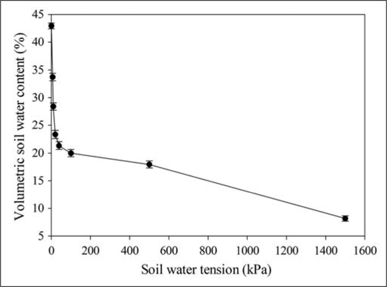
A soil moisture characteristic curve representing the mean moisture retention volumes of all collected samples is shown in Figure 1. Approximately 42% of the total mean volumetric water content was held as gravitational water (0 to 10 kPa), while approximately 66% of the total mean volumetric water content was held between 0 and 100 kPa. The large percentage of water held at low pressure potentials was expected, given soils were dominated by sand particle size fractions. Mean soil moisture retention volumes of communities ranged from 16.5 to 28.5 mL water 100 cm−3 soil between moisture potentials 0 and 100 kPa (Table 3). Significant differences in soil moisture content were observed among communities. The coefficient of variation for mean soil moisture content within communities ranged from 16.7% to 50.8% (Table 3). High variability between replicate samples was likely a result of heterogeneity in soil pore size and its correlated influence on soil moisture retention (Craul 1985; Jeetendra and Singh 2008). Low soil moisture retention values were a result of the high percentage of coarse, sandy textured soils (Goncalves et al. 2010). Soil moisture retention characteristics of urban residential soils have not previously been reported.

Mean soil water characteristic curve for all samples collected within nine newly established urban residential communities within central Florida. Error bars represent the standard error of the mean.
Soil characteristics of 40 lots within nine newly established urban residential communities in central Florida.
Soil Infiltration
Mean soil infiltration rates in communities ranged from 11.2 to 63.6 cm hr−1. Significant differences were observed among communities (Table 3). High variability in soil infiltration rate was also observed within communities. The maximum recorded infiltration rate was 111.1 cm hr−1, while the minimum rate was 2.0 cm hr−1. Similar infiltration rates and variability has been observed in related studies (0.3 to 220.0 cm hr−1, Pitt et al. 1999; 0.8 to 17.5 cm hr−1, Gregory et al. 2006).
Florida stormwater modeling and planning regulations require that management plans account for potential stormwater flow. Infiltration rates in 45% of sampled lots were below the 100-year, 24-hour design storm intensity of 26.7 cm hr−1 for Orlando, Florida (FDEP 2006). Further, 30% of sampled lots had infiltration rates below the 5-year, 24-hour design storm intensity of 16.5 cm hr−1. Thus, a large percentage of sampled lots would likely produce stormwater runoff under intense precipitation events. Penetration of landscape plant material roots into compacted urban soil may increase infiltration. Bartens et al. (2008) observed a 63% increase in mean infiltration rate as a result of black oak (Quercus velutina Lam.) and red maple (Acer rubrum L.) root penetration into compacted container soil. Authors attributed this observation to the formation of water channels along live root channels. Additional research examining the effect of plant material root growth on soil compaction and infiltration rate is needed.
Soil Bulk Density
Mean soil Db values ranged from 1.65 to 1.78 g cm−3 (Table 3). These values were similar to those observed by Gregory et al. (2006), where relationships between residential construction equipment use and soil compaction in northern central Florida were examined. Observed Db values were also similar to those found in newly constructed urban residential communities within Idaho and Washington states (Scharenbroch et al. 2005). Over 50% of sampled communities had mean Db values of approximately 1.75 g cm−3. When compaction density exceeds this value in predominately sandy soils, plant root soil penetration can be negatively impacted (Daddow and Warrington 1983; Voorhees 1992). Ensuring soil compaction remains below this threshold may be necessary when attempting to successfully transplant and establish plant materials in similar, newly constructed residential landscapes. Delineation of construction traffic zones are recommended to minimize unintended soil compaction (Randrup and Dralle 1997). Post-construction mechanical loosening of compacted soil and addition of organic amendments are recommended to decrease Db and increase soil macroporosity (Rivenshield and Bassuk 2007).
Soil compaction in newly constructed urban residential communities within central Florida had low variability at both small (lot) and large (community) spatial scales and was likely the result of similar, unintentional soil compaction that resulted from site leveling and grading practices. Variability of Db within each sampled lot was low. Coefficient of variation of Db within communities ranged from 3.3% to 7.6% (Table 3). Several individual lots were observed to have significantly greater Db values than other lots within the same community (data not shown). This trend was random and likely a result of additional site traffic or equipment storage on these lots. Visual observation was made of construction equipment and vehicular storage on random lots at the time of sampling. Efforts to avoid these lots during sample collection were made; however, it was not possible to determine if sampled lots had additional traffic-induced compaction prior to sample collection.
Although no housing structures were erected at the time of sampling, significant increases in soil compaction resulting from additional construction activities are not likely given the high soil compaction values already imposed. Assuming no additional soil disturbances occur, temporal decreases in Db are likely to occur as a result of improvements in physical, chemical, and biological soil characteristics (Scharenbroch et al. 2005).
Despite examining relationships between soil infiltration and soil moisture volume at various pressure deficits iteratively, no correlations were observed. Similarly, soil bulk density was not a significant predictor of infiltration rate here, although its relationship with infiltration is well established (Grabosky and Bassuk 1995; Jim 1998; Gregory et al. 2006; Pitt et al. 2008). Consistent construction practices likely caused uniformity among Db measurements, even though the study encompassed sites managed by various contractors. Regression analysis determined percentage total sand was the only significantly correlated variable to infiltration rate; however, percentage silt and clay were added to the model given their relationship to soil texture. Development of the regression model allowed for calculation of predicted infiltration rate. Relationships between recorded and predicted infiltration rate were examined (Figure 2). One outlier was omitted given its predicted value was >2 standard deviations from the recorded value. The coefficient of determination for the regression model was low (r2 = 0.43) and likely a result of high variability among recorded infiltration values.

Regression of recorded infiltration rate (dots) and predicted infiltration rate of soil within nine newly established urban residential communities in central Florida. Predicted infiltration rate was calculated through the regression model: Infiltration predicted = −1497.09 + 16.07 (% sand content) + 6.58 (% silt content) + 13.49 (% clay content).
CONCLUSIONS
In conclusion, study results provide a characterization of sandy soils within newly constructed urban residential communities in central Florida. Consistent, high Db values indicate potential plant root penetration concerns, while variable soil infiltration rates suggest potential for stormwater discharge from urban landscapes during intense precipitation events. Delineation of construction traffic zones and application of soil amendments may mitigate high soil Db and low soil infiltration rates observed in urban soils. Additionally, penetration of landscape plant material roots may increase infiltration rate and decrease stormwater runoff potential. Correlations between soil moisture retention volumes, bulk density, and soil infiltration rate were not observed to occur; however, soil texture was found to be a significant predictor of soil infiltration rate. Poor relationships between soil characteristics and infiltration rate suggest that direct measurement of soil infiltration is necessary for accurate stormwater discharge estimation.
Accurate landscape soil characteristic data is imperative to effective stormwater management. Urban soil characteristics should be considered unique and different from native soils. Planning and design of landscapes should assume increase bulk density and reduced infiltration compared to native soils (Randrup 1997; Randrup and Dralle 1997; Gregory et al. 2006). If stormwater management plans do not recognize the unique characteristics of urban soils, improper strategies may be developed.
Acknowledgments
This work was supported by the Florida Nursery, Growers and Landscape Association.
- © 2013, International Society of Arboriculture. All rights reserved.
LITERATURE CITED


Jump to section
Related Articles
Cited By...
- No citing articles found.