
Work by Kane and Ryan (1998) previously highlighted the potential of using GIS and GPS for locating hazardous trees in The Notch State Park in Massachusetts. During December 1997, application of this technique was being executed independently by the authors in the United Kingdom using different software packages (IDRISI and MapInfo) and GPS (Magellan ProMark X CP) hardware.
Among the number of GIS software packages available, IDRISI and Mapinfo have the most wide-ranging applications to land use. For this project, MapInfo was employed to process and store environmental and map data. Three tasks required attention prior to the analysis of data: 1) accurate cartographic survey and grid referencing of the area’s features including tree positions; 2) formatting of map data to construct a GIS map; and 3) in-depth tree survey data collection including hazard assessment and amenity valuation.
Methods
Landscape features were mapped using Magellan Global Positioning Systems (GPS) handheld receivers. Sufficiently accurate positioning of features such as individual trees was accomplished using 2 receivers: a stationary base station receiver left at a known reference location and a “rover” receiver used in the field to map the various features.
The satellite signals upon which the GPS operates have a degree of error. This is a compositional error partly deliberately induced for United States national security reasons and partly technologically and environmentally induced. Processing of the 2 sets of data from the base station and the rover removes most of the error from the final data coordinates.
Walking along features such as tracks or the boundaries of different land cover areas, carrying the rover receiver, allowed mapping of these features to an accuracy within ± 5 m (16.4 ft). Leaving the rover receiver stationary at the base of a tree for 6 minutes allowed locations of individual trees to be mapped to an accuracy of less than ± 1 m (3.3 ft).
The GPS data were used to construct GIS map layers representing the tree locations and land cover areas (Figure 1, next page).
These map layers could then be spatially overlaid to a computerized base map. The base map in this project was digitally drawn into the computer from an existing British Ordnance Survey (OS) map and provided the spatial context for the other map layers. The GIS database was constructed using MapInfo software, as was the map.
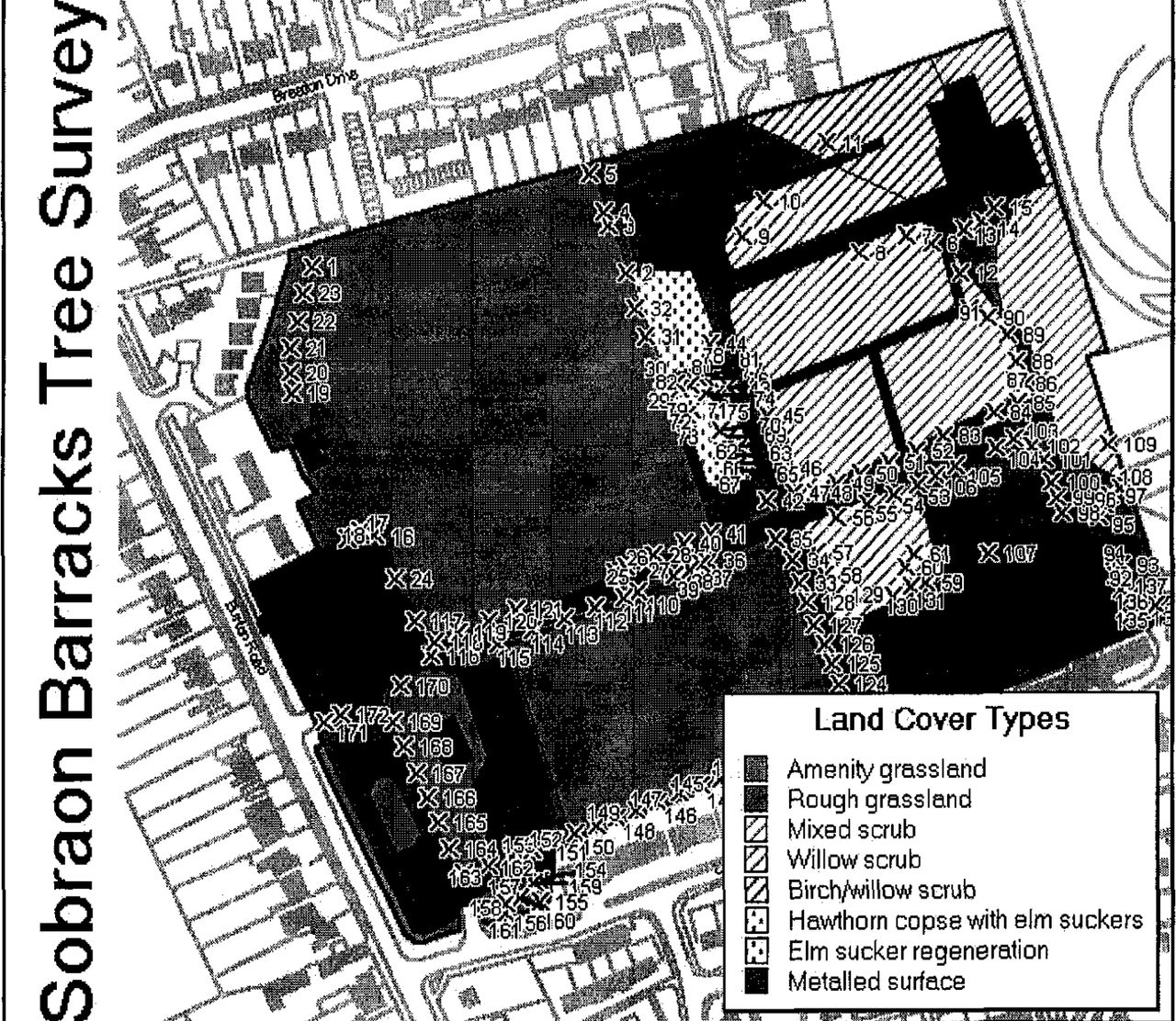
Tree locations and land cover types.
Tree Survey Data
The following detailed site data collected from the tree survey were entered into a GIS database:
tree number (for initial location during the survey)
map reference (6-figure OS coordinates)
species
dbh (millimeters)
clear trunk to first branch (meters)
mean crown diameter (meters)
height (meters)
amenity tree values (Helliwell 1994)
health and structural assessment recommendations
Each record from this database was automatically linked to the appropriate tree location on the GIS map.
The amenity tree valuation system uses size, life expectancy, importance of positioning in the landscape, presence of other trees, form, and special factors (Helliwell 1994). A hazardous tree assessment procedure was employed to evaluate the structural stability with reference to public safety (including a climbing inspection of selected trees).
Discussion
The computer map and accompanying database gave a greater facility for tree managers in this project to
provide a detailed and accurate map to locate trees and designate land usage
provide precise locations of trees with their dimensions (e.g., crown spread)
allow selective display of map information (e.g., positions and numbers of all trees requiring crown reduction)
facilitate rapid selection and display of selected database information
determine areas within which construction and development can be accomplished without damage to trees
carry easily accessed and easily updatable information on tree valuations, health, etc.
Figure 2 (next page) shows how GIS allows map and database information to be integrated. Trees displayed require removal.
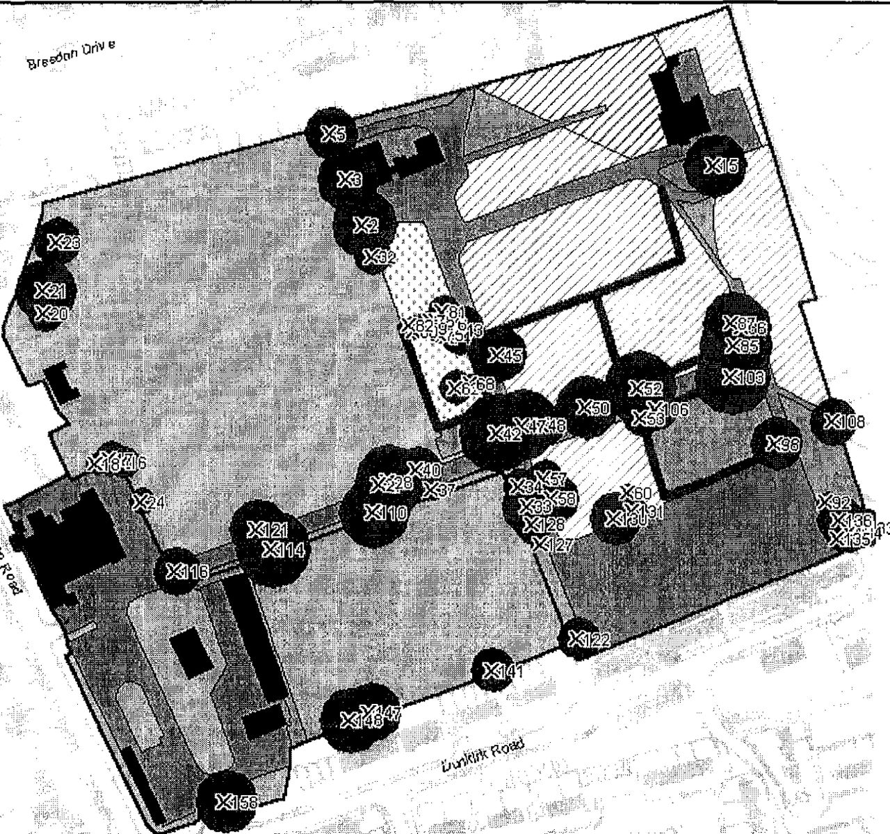
Integrated map and GPS information showing all condemned trees requiring removal.
Conclusion
Global positioning systems allow rapid and accurate mapping of landscape features while the use of geographic information systems technology allows rapid access, processing, and updating of tree survey data. The use of this data in the field using a laptop computer should aid the professional tree surgeon in determining that he or she is dealing not just with the correct trees, but that the arboricultural information is up to date and accurate.
This system is of special value in refining recording systems for tree inventories, thus making the procedure simpler, more efficient, and able to be used in the field. Indeed, barring financial expense, there is no technical reason why such an electronic system should not be vehicle based with additional database and map information being transmitted from a central office location.
Acknowledgements
The authors thank the Lincoln City Council Planning Department for their permission to publicize contractual information, their enlightened approach to tree preservation, and their willingness to test a previously untried approach to arboricultural management. Thanks particularly to Jill Wilson, LCC Department of Planning. Thanks also to Dr. Melanie Smith, whose consultations resulted in the project being implemented.
Ordnance survey maps reproduced by permission of Ordnance survey on behalf of HMSO © ED/161A.
- © 1999, International Society of Arboriculture. All rights reserved.
In this issue


Jump to section
Related Articles
Cited By...
- No citing articles found.